As technology continues to evolve, sophisticated equipment emerge as well, such as the marine GPS and chart plotters which are specifically designed to aid in cruising and fishing. For anyone who has been at sea, it is inherently difficult to pinpoint the right direction when all the four directions are water surroundings. In such scenario, a marine GPS Chart-plotter becomes absolutely indispensable.
In order that you settle for the best brand and highest form of functionality, we’ve put together a selection of the top 7 best marine gps chartplotters you should consider.
Top 7 Best Marine GPS Chartplotters
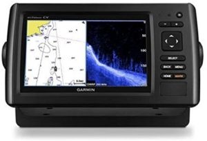
1. Garmin GPSMAP 1242xsv
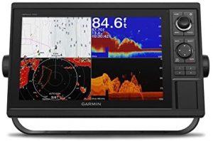
In this model, Garmin invested in the provision of clearer-scanning sonar, giving a clear view of the water surrounding the boat. The system integrates the popular 10Hz internal GPS and GLONASS module, meaning that it refreshes one’s position up to ten times within a second to offer the most accurate locks.
It is capable of harboring up to 5,000 waypoints, 100 routes and 50 tracks. Just like most Garmin chart plotters, this unit comes with BlueChart charts and LakeVü HD maps. It is capable of executing two functions which are related to navigation as well-shallow water shading and quickdraw contours. The latter allows users to manually draw contours of particular water bodies in case they are not available on the charts provided whereas the former avails color coding to serve the different depth ranges.
Additional features which make the pack exceptional include:
- Sophisticated CHIRP sonar technology
- GPX waypoints transfer feature
- IPX7 waterproof rating
- Color WXGA display
- Tide Tables
2. Garmin ECHOMAP Ultra 126sv
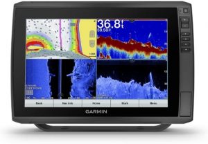
This system is mostly recognized for its preloaded Blue Chart g3 coastal charts and LakeVu g3 inland maps which cover the Canadian Great Lakes, the Gulf of Mexico and the U.S East and West Coasts. It also includes every spec that is available within NOAA charts, which is why it offers a smooth form of transition from the zoom level to continuity across the given chart boundaries. Other features which characterize these charts include tidal stations, depth contours, fishing charts and IALA symbols, making them most expedient charts.
Garmin ECHOMAP Ultra 126sv is built using a diagonal 12-inch screen which is WXGA display to offer a high degree of clarity. The pack is also synonymous with the GT54UHD-TM Transducer, which is globally recognized as a temperature-capable inclusion that has both trolling motor and transom mounts. Customers looking to buy this unit should also expect several functions associated with the 2D sonar and these include fish alarms, bottom lock and A-scope.
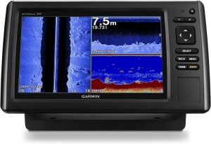
3. Garmin ECHOMAP Ultra 106sv

This is a combo GPS/fishfinder, paired with a keypad-controlled chart plotter, a SideVu Transom mount transducer as well as the mid-range CHIRP ClearVu. It comes with Bluechart G3 charts which cover the U.S coastal regions, not to forget a highly functional 10Hz internal GPS antenna. The display screen is 10-inches and keypad-controlled touchscreen screen which accurately and swiftly locates positions as a result of the internal antenna.
Thanks to the ECHOMAP Ultra & ECHOMAP Plus combo, it is now possible to view the highest quality sonar images of all that is beneath and beside the boat. Perhaps the newest feature in the echoMAP CHIRP series is the inclusion of Quickdraw contours, giving users the ability to personalize their fishing maps. The software that is included in this package therefore allows users to not only create maps but also improve the existing ones. The system has emerged to be a top choice for most cruisers because it is simple to install and operate. Other standout features include:
- Panoptix compatibility
- Tilt Gimbal mounts
- Flush mount kit
- Quick release cradle
- NMEA 2000 connectivity
4. Garmin Echomap Chirp 94SV
This is a highly-functional gps unit produced by Garmin featuring the ClearVu scanning sonar technology. The unit is endowed with a transducer, Bluechart g2 charts, Lakevü HD maps and Coastal Mapping for coastal marines. As the name alone suggests this is a chart plotter which has 5HZ internal GPS/Glonass module, with the capability of offering heading updates and positioning at least five times within a second.
It is preloaded with the popular Bluechart g2 chart and Coastal Mapping covering the U.S coastal waters, the Gulf of Mexico, Great Lakes and the East Coast. The entire pack is designed to offer the smoothest transitioning between excellent continuity and zoom levels across various chart boundaries. Some of the functions that it boasts of include:
- Currents
- Tidal stations
- IALA symbols
- Depth contours
The fishing charts which are located adjacent to the base charts are characterized by bathymetric contours which have little to no visual clutter. There are also safety shading options within the unit, with the capability of designating up to 10 depth ranges which are immediately assigned to the depth contours to ease the noticing of target depths from a single glance. The unit is light in weight, making it one of the most convenient chart plotters in the market today.
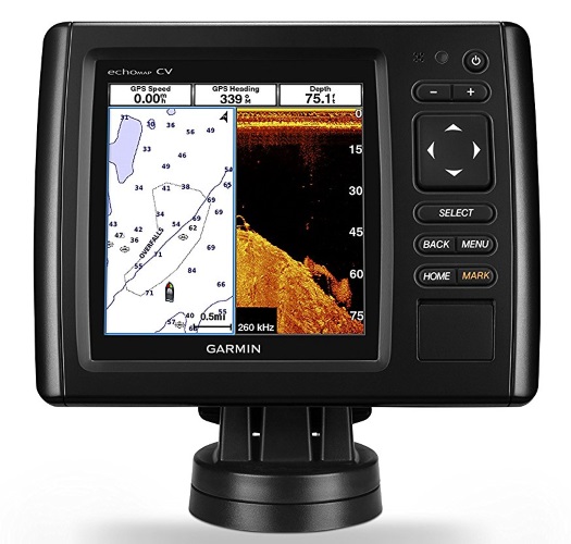
5. Garmin Echomap Chirp 74Cv
Garmin Echomap Chirp 74Cv may be a small unit featuring the clearVu sonar and traditional 2D but it must be appreciated that both are CHIRP enhanced. It is built in such a way that it can use CHIRP sonar technology in both the ClearVu and 2D versions. The transducer that this unit boasts of has the popular 8-pin connectors, not to forget both trolling motor and transom mounts.
It has the capability of 50/77/200 kHz frequencies for the 2D version and another 260/455/805 kHz for the clearVu version. The sonar features dual frequency, meaning that two 2D frequencies can be utilized simultaneously and returns from both can be viewed at the same time with the help of a split screen.
The system has a maximum depth capability of 2,300 ft, but this is exclusively for fresh water. When used alongside the supplied transducer, the system is able to scan waters to a depth of 1800 ft for the 2D version and another 1000 for the ClearVu version. Like the previous line of systems, this version is capable of offering multiple sonar-related functions which include:
- Sonar recording
- Sonar rewind
- Bottom lock
- AIS support
- Data graphs
Its unique endowments include the LakeVu HD charts which come along with the system, covering more than 17, 000 rivers, reservoirs and lakes in the United States. The charts are also synonymous with points of interest such as docking areas, interstates, marinas, boat ramps and camping spots, all of which make it a suitable system.
6. Raymarine Marine Dragonfly Pro 7
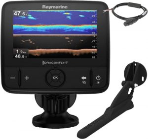
This package offers new technology and improved specs, with Navionics SonarChart which cover both Canadian and U.S lake regions and coastlines. The built-in GPS antenna gives the most accurate position, coupled with a dual channel CHIRP sonar which ensures that advanced underwater pictures are taken to provide a structure and fish images that contain near-photo-like details. Dragonfly Pro 7 has Wi-Fi capabilities as well, enabling the angler to effortlessly share the sonar images with compatible smartphones and tablets via wireless technology.
The package has Downvision sonar, capable of offering the most spectacular view of the sea floor. Combined with the CHIRP technology, therefore, the resultant target separation and image clarity cannot be paralleled. The system similarly has CPT-DVS transom mount transducers, enabling easy and quick installation. There is a 72-channel in-built GPS receiver (covering up to 3,000 waypoints and 15 tracks with each track containing up to 10,000 points).
7. Garmin GPSMAP 78sc
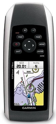
This is a rare system which is able to float on water, unlike most of the GPS and chart plotter packs that are installed in water vessels. The display screen is relatively small, albeit excellent for a handheld device. The strength of this screen does not fall within the confines of its size but rather the ingenious color display which makes it possible to view angles in an excellent manner.
Unlike other GPS devices, this model has a wasp receiver which boasts of 12 different channels. This means that even the minor corrections are received accurately and quickly. The pack features an in-built barometer as well, which measures both altitude and atmospheric pressure. For a device its size, one cannot expect to have a 3-axis compass but this is precisely what the package offers, enabling it to draw the right direction from a stationary position. Other supportive features include:
- AA batteries which run for more than 20 hours
- A separate chart slot
- A GMP map
Conclusion
GPS and chart plot systems differ in size, sophistication and functionality. When choosing the best device, it is important for a user to consider the purpose for which they will use the device, the budget range that they have and precise functionalities that they need. It is important to consider the brand reputation, the kind of sonar device that comes along as well as the depth range that such a device is endowed with. All these combined, it is justifiable to conclude that this article has top-rated devices only.